HM Fire Service Inspectorate: local area inspection - Angus
Related Downloads
2_About the area
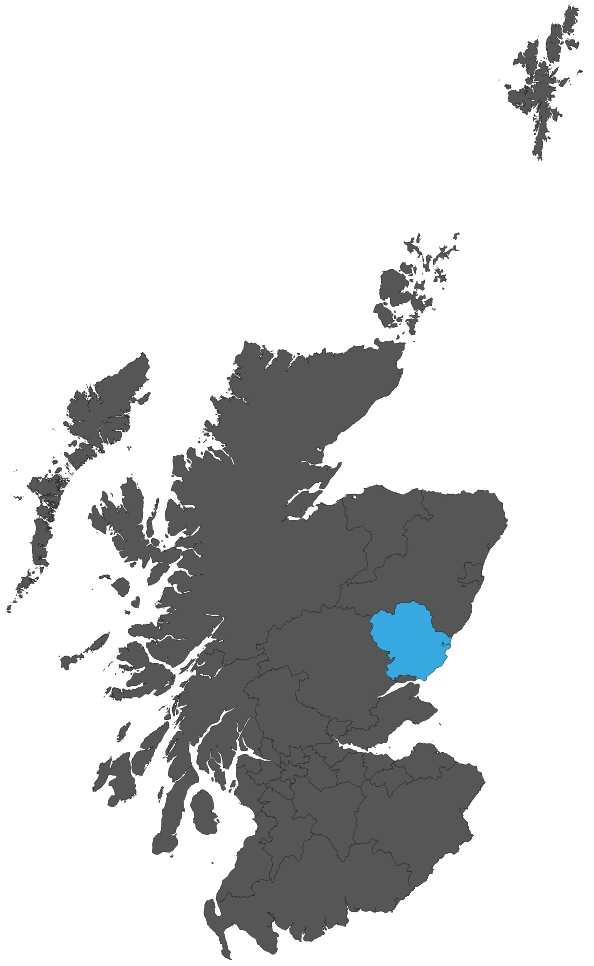
14. Angus is the area shaded blue on the map in Figure 1. It covers an area of around 842 square miles. Approximately 75% of the population is concentrated primarily within the seven main towns of Forfar, Kirriemuir, Montrose, Brechin, Arbroath, Carnoustie and Monifieth. Angus has a border with the local authority areas of Dundee City, Perth and Kinross, and Aberdeenshire. In terms of the SFRS organisation structure, Angus is within the North SDA.
15. Angus is divided into eight council wards.
16. The population of Angus at the end of June 2019 was 116,200[1] making it the 17th-highest populated of the 32 local authority areas in Scotland. This is an increase of 0.1% from 116,040 in 2018. Between 1998 and 2019, the 25-to-44 age group saw the largest percentage decrease (-17.9%). The 65-to-74 age group saw the largest percentage increase (+47.5%). Around 2% of the Scottish population reside in Angus. The percentage of the population aged 65 and over, at 23.9%, is more than the overall percentage for Scotland of 19.1% in that age band. The ethnicity of the population of Angus as at the 2011[2] census was classified as 98.7% white (Scottish White: Other British White: Irish White: Other) and 0.8% Asian, Asian Scottish or Asian British, with a further 0.5% classing themselves as an other ethnic group.
17. There are various operational risks in the area, including, major trunk roads, railways, harbours and ports, and various commercial, industrial, military, and heritage risks.
18. There are six fire stations in Angus. The locations are shown in Figure 2. Table 1 shows the fire station duty system, the resources based there and incident activity for 2020/21.
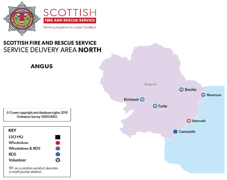
| Fire station | Duty system | Appliances | Activity* |
|---|---|---|---|
| Arbroath | Wholetime/ RDS | 1 Rescue pump 1 Water tender ladder (RDS) | 397 |
| Brechin | RDS | 1 Rescue pump 1 Water tender ladder | 174 |
| Carnoustie | RDS | 1 Rescue pump | 104 |
| Forfar | RDS | 1 Rescue pump 1 Water tender ladder 1 Environmental Protection Unit | 269 |
| Kirriemuir | RDS | 1 Rescue pump 1 Water tender ladder | 106 |
| Montrose | RDS | 1 Rescue pump 1 Water tender ladder | 288 |
*This is the number of times that an appliance from the fire station attended an incident. It is not an indication of the number of turnouts. The IRS data on which the activity totals are based exclude mobilisations which did not result in a direct incident attendance, for example, stand-by or where the appliance was turned back.
Employees[3].
19. The SFRS has 133 staff posts in the area; 7 (5.2%) of the staff identify themselves as female. The ethnicity of staff, where declared, reflects that of the local community.
Incident Statistics
20. Table 2 shows the number and type of incidents attended by the SFRS in Angus over a period of four years[4].
| Incident type | 2017/18 | 2018/19 | 2019/20 | 2020/21 |
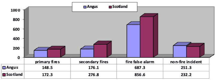
|---|---|---|---|---|
| Primary fire | 161 | 168 | 179 | 172 |
| Secondary fire | 182 | 201 | 145 | 204 |
| Chimney fire | 24 | 18 | 12 | 21 |
| Road traffic collision | 67 | 48 | 50 | 49 |
| Other non-fire incident | 211 | 207 | 214 | 242 |
| False alarm (including non-fire false alarm) | 1,012 | 988 | 907 | 802 |
| Total incidents | 1,657 | 1,630 | 1,507 | 1,490 |
Figure 3 below gives a visual reflection of the make-up of incidents within Angus for the most recent available statistics, 2020/21.
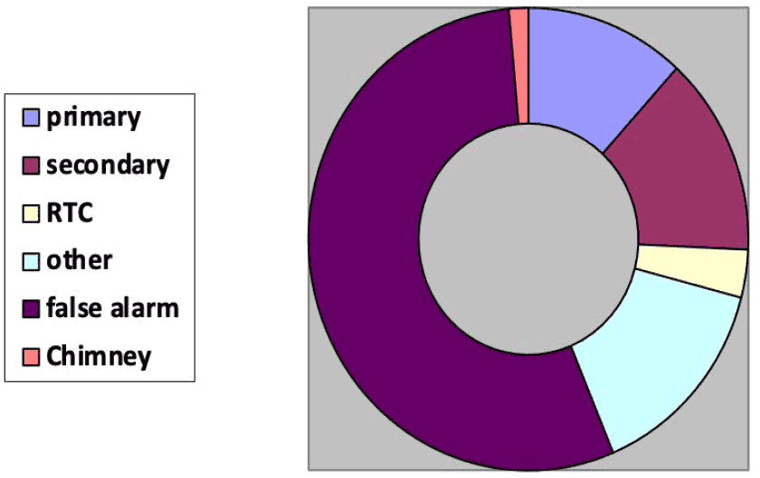
21. Responding to false alarms represents 53.8% of all incidents attended by the SFRS in Angus in 2020/21. Unwanted fire alarm signals (UFAS) from non-domestic premises made up 270 of these false alarms and therefore comprise 18.1% of all incidents. This equates to a rate per 100,000 population of 233.1 for Angus, which is below the rate for Scotland of 399.2 for UFAS incidents.
22. The incident rates for 2020/21 are shown in Figure 4 benchmarked against the rates for Scotland. In Angus the rates per population for primary fires, secondary fires, fire false alarms are lower than the figures for Scotland; however, non-fire incidents are higher than for Scotland.